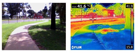
Towns' hot spots mapped
Published on 31 January 2019

Gannawarra Shire Council was one of nine councils in the region to recently take part in the Cool It project, which helped participating municipalities improve community resilience to increasing heat in regional Victoria.
Project developers used existing spatial data to determine urban areas within the participating municipalities that were socially vulnerable to heat impacts.
“Various data, collated by the Victorian Government, the 2016 Census, open sources and aerial imagery, helped to identify parcels of urban areas where populations are most vulnerable to urban heat and heatwaves; and to prioritise parcels of urban areas that are also exposed to more heat due to a combination of high pedestrian activity and hot urban surfaces,” Council’s Director of Infrastructure and Development, Geoff Rollinson said.
“Urban Forest Consultants and the University of Melbourne were then appointed to develop methodology suitable for smaller shires and rural cities to utilise existing and freely available datasets to identify focus areas.”
The mapping enables councils to instantly prioritise areas for cooling interventions, including:
- Tree planting programs (in both streets and parks);
- Irrigation programs of open space;
- Where to position “shady walkways and cycle ways”;
- Where to prioritise Water Sensitive Urban Design for cooling; and
- Capital works, strategic planning and other planning measures.
“The Department of Environment, Land, Water and Planning funded the project, with regional councils taking part in partnership with the Central Victorian Greenhouse Alliance,” Mr Rollinson said.
Other participating municipalities were the Ararat Rural City Council, City of Ballarat, Buloke Shire Council, Central Goldfields Shire Council, City of Greater Bendigo, Mildura Rural City Council, Pyrenees Shire and the City of Whittlesea.